T.L. Sullivan | The Weekly Ledger News | Winter Weather Update from the NWS in Birmingham
Birmingham, Ala. – The forecast is trending towards less snow and more sleet and freezing rain (ice), as our high-resolution models are starting to pick up on a pocket of air a couple thousand feet above the ground that will be a little above freezing.

While sleet and ice certainly aren’t as fun to play outside in as snow, this does not change the impacts in our forecast. There will be dangerous travel conditions developing after midnight tonight and continuing through the AM commute, especially in the dark blue and purple areas.
Stay home tomorrow morning if you can. If you do have to get out, leave plenty of space between the car in front of you and avoid sudden braking or accelerating. Temperatures warm above freezing by noon in most areas, as precipitation changes over to rain.
However, temperatures in the higher elevations of northeastern Central Alabama will remain at or below freezing tomorrow afternoon/night, where ice may continue to accumulate and power outages may result. For all of Central Alabama, black ice will be possible on the roads by Saturday morning.

(3:15 p.m. update from the National Weather Service in Birmingham)
Overview: A wintry mix of snow, sleet, and freezing rain will move in from the west after midnight tonight. Temperatures at or just below freezing will result in difficult travel conditions for the Friday morning commute, especially across the northern half of Central Alabama. Temperatures will warm a couple of degrees above freezing during the day, with precipitation changing over to rain across much of the area by midday.
However, areas in far northern and northeastern Central Alabama will stay a bit cooler, keeping at least some potential for wintry precipitation continuing into Friday afternoon and evening there. Small fluctuations in temperatures at the ground and above the surface, as well as the intensity of the precipitation, will play a large role in precipitation type and accumulations and associated impacts.
The greatest concern for significant impacts will be in the newly issued Winter Storm Warning area, where heavy wintry precipitation could quickly accumulate, especially during the morning commute when temperatures will be near or below freezing.

Highlights:
What:
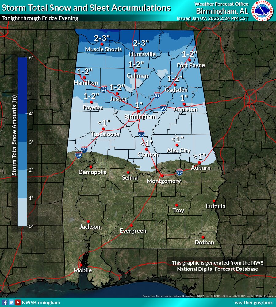
* Snow and sleet accumulations of 1 to 3 inches in the Winter Storm Warning counties.
* Accumulations of 0.5 to 2 inches of snow and sleet in the Winter Weather Advisory counties.
* Ice Accumulations of 0.10″ to 0.25″ with the highest accumulations in the northeastern counties.
* Any residual water or moisture on roads may refreeze and lead to black ice formation from Friday night into Saturday morning.
Images courtesy of National Weather Service in Birmingham.
Where:
* Areas generally north of Highway 80 and Interstate 85, with the highest accumulations along and north of the I-20 corridor.
* Black Ice potential – all of Central Alabama
When:
* After midnight tonight, lasting through around midday Friday. The exception will be far northern and northeastern portions of Central Alabama where wintry precipitation may linger into Friday evening.
Impacts:
* Travel conditions may become difficult to dangerous for areas in the Elevated and Significant impact areas, (Counties included in the Winter Storm Warning) especially through Friday morning.
* Slick spots may develop on area roadways, especially bridges and overpasses north of Highway 80 and Interstate 85, within the Winter
Weather Advisory counties.
* Continued slick spots on roadways due to black ice Friday night into Saturday morning.
Continue to follow The Weekly Ledger News for all your up-to-date winter weather information.
.png)


Comments